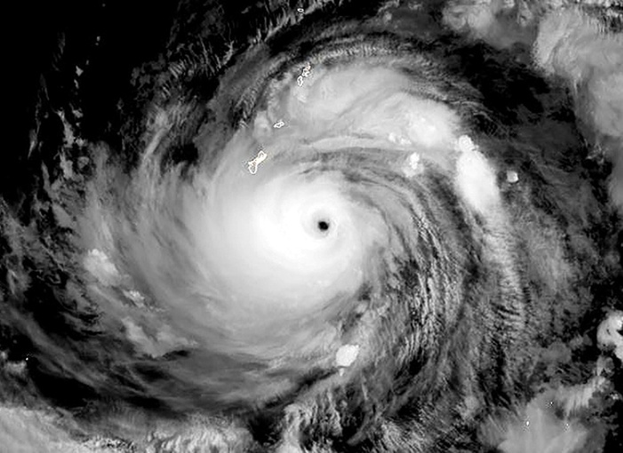
Typhoon Mawar was expected Wednesday to bring catastrophic winds directly to Guam, a US territory in the Pacific that is home to a crucial military outpost.
The storm's top winds had weakened slightly but it remained a dangerous Category Four typhoon with maximum sustained winds of 140 miles per hour (225 kilometers per hour), and gusts up to 175 mph at landfall, the National Weather Service (NWS) said.
On its current trajectory, Mawar will pass "directly" over the island, which has a population of about 170,000, unleashing torrential rains and extreme flooding, the forecaster said.
As of 1:31 pm Wednesday local time (0331 GMT), the storm was 45 miles (70 kilometers) southeast of the island, the NWS office in Guam said in an advisory.
"Conditions are gradually deteriorating across Guam. Winds are steadily increasing and it is getting louder outside," the NWS said, adding that winds of 53 miles per hour had already been recorded.
"I am worried for the safety of our people. This is the first storm of this magnitude for 20 years," Guam Governor Lou Leon Guerrero said.
Mawar lost its super typhoon status when its sustained winds fell below 150 mph but the NWS in Guam reported that the typhoon "may strengthen slightly on approach to Guam."
- Coastal evacuations -
Authorities ordered the evacuation of low-lying coastal areas, especially in the flood-prone southern villages.

Winds near the eye wall could bring major damage to buildings and homes made of light materials, such as non-concrete roofs and walls that are not made of reinforced concrete.
A calamitous storm surge threatens to wreak havoc on shorelines, and large boats "could be torn from moorings."
"Surge may reach to between 20 and 25 feet above normal high tide for the most vulnerable storm surge prone areas near the eye wall," the NWS said.
Forecasts predicted Guam will receive rainfall of 10 to 15 inches, with some areas experiencing 20 inches or more, the NWS said.
These in turn could trigger landslides in the central and southern parts of the island, the weather service warned.
"Residents who are in need of shelter need to seek shelter no later than 9AM as we expect the storm to intensify in the next few hours," Guerrero said in a Facebook post.
People have been asked to stay inside and away from windows, and not venture outside during temporary lulls as flying debris can cause serious injury.
Guam's Office of Civil Defense urged motorists to stay off the roads on Wednesday, saying "winds are expected to intensify to typhoon force winds by midday."
- US military presence -
Some 21,700 US military personnel and their families are based at or near several facilities on Guam, which routinely hosts nuclear attack submarines and long-range bombers.
It is also home to crucial electronic listening posts.
The US bases also have some of the Pacific region's most significant ammunition and fuel storage facilities.
President Joe Biden declared a state of emergency for Guam on Tuesday so that federal aid can be provided to the island, according to a statement from the White House.
About 60 flights departing from or arriving in Guam and scheduled between Tuesday and Thursday have been canceled, A.B. Won Pat International Airport said.
Conditions are predicted to improve on Thursday.
bur-ia/mca/qan
© Agence France-Presse
Your content is great. However, if any of the content contained herein violates any rights of yours, including those of copyright, please contact us immediately by e-mail at media[@]kissrpr.com.
Source: Story.KISSPR.com

